↓
 

Wetumpka Land Surveying

Land Surveying in Wetumpka, Elmore County, Alabama

Wetumpka Land Surveying
  • Home
  • ALTA Survey
  • Boundary Surveying
  • Drone LiDAR Mapping
  • Elevation Certificate
  • Land Surveying
  • Topographic Survey
  • Other Services
    • Lot Survey/Closing Survey
    • Construction Survey
  • Civil Engineering
    • Expert Witness
    • Elevation Certificate – LOMA
  • Contact Us
    • Montgomery, AL
    • Prattville, AL
    • Wetumpka, AL
Home→Categories GPS

Category Archives: GPS

Using GPS to Track You – Is It Real?

Wetumpka Land Surveying Posted on February 15, 2015 by WetumpkaLSApril 5, 2021
licensed land surveyor

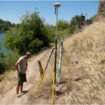
A licensed land surveyor trusts his GPS system like  his gun in a battlefield. Though it sometimes do not provide all the info that you may need, it is nonetheless very helpful in producing an accurate boundary survey. Many have … Continue reading →

Posted in blog, GPS, land surveyor | Tagged GPS, Land Surveying

Using GPS in Land Surveying

Wetumpka Land Surveying Posted on January 30, 2015 by WetumpkaLSJanuary 20, 2018
montgomery land surveying

Land surveying is a profession that greatly utilize the GPS system. Today, man-made constellations are in orbit. Their purpose is to provide instant, exact and global positioning information. This global positioning system of GPS is revolutionizing the modern construction sites, … Continue reading →

Posted in blog, GPS, land surveying, land surveyor | Tagged GPS, GPS land surveying, land surveyor
©2025 - Wetumpka Land Surveying - Weaver Xtreme Theme
↑